Places
36 places found.
Those places high-lighted have photos. All locations may have maps, books and memories.
- Bangor, County Down
- Newcastle, County Down
- Greyabbey, County Down
- Donaghadee, County Down
- Downpatrick, County Down
- Portaferry, County Down
- Dromore, County Down
- Downings, Republic of Ireland
- Hillsborough, County Down
- Killyleagh, County Down
- Ardglass, County Down
- Rostrevor, County Down
- Dundrum, County Down
- Newtownards, County Down
- Warrenpoint, County Down
- Ballygowan, County Down
- Ballywalter, County Down
- Ballyward, County Down
- Bishops Court, County Down
- Boardmills, County Down
- Culcavy, County Down
- Katesbridge, County Down
- Killough, County Down
- Millisle, County Down
- Portavogie, County Down
- Saul, County Down
- Seaforde, County Down
- The Diamond, County Down
- Audleystown, County Down
- Kearney, County Down
- Annaclone, County Down
- Ballyhalbert, County Down
- Ballymartin, County Down
- Clare, County Down
- Conlig, County Down
- Dollingstown, County Down
Photos
1,089 photos found. Showing results 1 to 20.


Maps
459 maps found.


Books
47 books found. Showing results 1 to 24.

Memories
8,130 memories found. Showing results 1 to 10.
Indigo
Hi, Anyone remember a shop called Indigo in Dartford? I used to go to Dartford on the train, with my mum, once in a while, and I remember a shop called indigo, I can’t remember what it sold (I’m guessing jeans) It’s a memory that’s stuck in ...Read more
A memory of Dartford
A Memory Of Heswall Children's Hospital
Anybody remember me in Heswall Children’s Hospital. My name then was Veronica Roberts I had a RTA on the way home from school beginning of summer 1957.I had a broken leg, concussion and a broken nose. I had my ...Read more
A memory of Heswall by
1944 Vi Flying Bomb
This isn't really a memory because I was too young at the time. I was born in a timber bungalow called "Midway" on Lowford Hill, Bursledon in April 1942. Dad was working at the Follands aircraft factory at that time, building ...Read more
A memory of Bursledon by
Caravan Holiday In 50s
My parents had a caravan at The Old Coastguards close to Seasalter Sailing Club from 50s to 70s. It had only 3 caravans on it. I regularly got up early as a child to accompany the site owner, a super guy, while he followed the ...Read more
A memory of Seasalter by
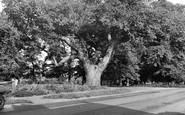
The Oak Tree
The Oak Tree was amazing, and big enough to hide behind as a small child. It was a key feature throughout childhood. It was a shame when it was cut down. It is near the Berristead, the Elizabethan manor house, and was allegedly planted by a Tudor, though not sure who.
A memory of Wilburton by
Bexleyheath Circa 1950's
I lived in Faygate Crescent, Bexleyheath. Schools I remember attending are Upton Rd, Gravel Hill and Bexleyheath Secondary Modern. I have fond memories of chatting to the girls school across the playing fields from ...Read more
A memory of Bexleyheath in 1950 by
Good Times
I lived in Belsize Road, Swiss Cottage end for many years from the 50s through the 60s till i got married, I remember lots of things, the buses getting stuck in the road going up to Swiss Cottage in the snow and ice and having to be ...Read more
A memory of Swiss Cottage by
Post War Harlesden.
I was born in Tredegar, South Wales in April 1941. My mother had been evacuated to that small welsh town when she fell pregnant with me in 1940. We lived with her parents. My dad was away doing War things. We moved back to London ...Read more
A memory of Harlesden by
Shops
I suspect this is a little earlier than 1960 (but after 1956) the first building on the right was the offices of "Waugh Brummell and Barron" later Waugh & Co Solicitors and still going strong. The original Waughs were prominent in the ...Read more
A memory of Haywards Heath
Names Of People And Buildings.
Here we are looking down West Street with the village school visible at the end. On the left is Tetts Farm with the milk churns, while next is Manor Farm, farmed by Reg Newick. The thatched building before the ...Read more
A memory of Hinton St George
Captions
2,258 captions found. Showing results 1 to 24.

The houses on the right are Nos 18 and 20 Downs Road, formerly called Fanfare Road when built on the northern slopes of Farthing Down.

This scene is of Banstead Downs, which are actually outside Sutton's boundaries, south of Belmont station.

We are looking down Cross Square to the magnificent Cathedral.

As we turn down Higgs Lane, this is what we would see looking back towards the main road.

This picture looks eastwards down Main Street to Quarry Hill (left) and Eype Down (right).

Even as late as 1957 the 'Royal Daffodil' carried 144,000 passengers down to Margate in a ten-week period.

There was a great fire in 1600 in Gamlingay, and most of the buildings along Church Street were burnt down.

The view down the town's busiest trading place begins with grocer and wine merchant Sarah Chapman's shop front (left) facing the Volunteer Inn (far right), where the landlord was Tom Searle.

This well-known public house stands at the foot of the Downs.

Here we have a view looking into Longsmith Street, which leads down to Bearlands police station and the courts.

This view, now on the South Downs Way long distance footpath, looks down towards Eastbourne past Meads.

The narrow steeply- sloping Union Street, east of the church of St James, leads the eye northward out of town and towards the stark ridge of Peaked Down; its visible notch gives the down

At Fulking, 16th-century cottages still lie on either side of the village street that winds its way below the South Downs.

This picture was probably taken just down the road from Penventon Farm.

Cobbled Front Street slopes steeply down towards the South Tyne Valley, past 17th-century cottages, like that on the extreme right which is dated 1681, and ancient pubs like the Angel and the King's
Further down the Thames are the Houses of Parliament - or rather, the Palace of Westminster.

We are looking down on the village from the site of a Roman camp.

The village slipway, up and down which fishing boats are still hauled to protect them from winter storms, is down the road to the left.

We have moved away from the river, and are looking down one of the main city streets; the scene nowadays has changed little.
The narrow steeply- sloping Union Street, east of the church of St James, leads the eye northward out of town and towards the stark ridge of Peaked Down; its visible notch gives the down

Modern buildings have crowded in along the northern part of Betchworth's long village street, but the line of the North Downs and the big chalk pit remain much the same, although the downs are far more

Donkeys were used to transport everything up and down Clovelly's steep street: herring, coal and lime came up the hill from the harbour, along with tourists who could not face the walk, while mail and

In this picture, Anton Mill, some distance down-river beside Barlows Lane, can be compared with the Town Mill.

We are looking down Castle Hill, by the wall of Lancaster Castle.
Places (198)
Photos (1089)
Memories (8130)
Books (47)
Maps (459)

